
Jet Departures from Livermore Airport: Study of Tracks and Altitudes
Introduction
Livermore Airport (LVK) for a number of years has had a voluntary noise abatement departure advisory for VFR departures and arrivals. The principal effect of this advisory is to avoid unnecessary overflight of the residential area that begins 1.4 nautical miles directly west of the departure end of Runway 25R. However, it seems that many of the noise complaints that originate from this residential area regard jet departures (a variety of jets arrive and depart LVK each day). Jets invariably depart IFR and follow the LVK Three Standard Instrument Departure (SID). Throughout the year winds typically favor many more departures to the west than to the east, and the route specified by the LVK Three SID will take jets over this residential area unless the pilot executes a high climb gradient and starts the right turn immediately upon reaching 1200 feet MSL. Most do not and the data presented here demonstrates this.
These jet aircraft using the airport originate from all over the United States and it would seem that most of their pilots would not be aware of the noise sensitivity of the neighborhood beginning 1.4 NM west unless the airport provided some sort of advisory like that found in the voluntary advisory for VFR traffic. The data also suggests some pilots seem to be aware of the problem as evidenced by executing a steep climb gradient and making the right turn in the SID at 1200 feet MSL taking the aircraft north prior to overflight of the neighborhood. It is likely these pilots may use LVK often and are aware of the problem.
Data Capture of Jet Traffic Departing LVK
A system was developed and deployed (hardware and software described below) that captures and records the ADS-B data stream from the aircraft the moment it leaves the runway surface upon departure. Software additionally conducts analysis and generates a map with the aircraft’s track with certain points annotated with the corresponding altitude. One point also is annotated with airspeed and vertical rate of climb. The altitudes relate to barometric pressure and are adjusted for local altimeter setting by using the airport elevation of 400 feet above mean sea level (MSL) as a reference. Various points on the airport vary from 379 to 400 feet MSL. Climb gradient is also computed after aircraft lift off. Lastly, a public database was used to identify the aircraft’s call sign and jet type.
The map listing below is some of the data captured over several days. Not all jets departing LVK were captured given that the system was not in full operation, but those listed below show the point being made in this post. The list is the date and instant of time at which the jet departed the runway. The six characters at the end are the aircraft’s unique ICAO identification code. Clicking on an item in the list brings up the corresponding map.
- 2022-04-05_114547-0700_a35ad3
- 2022-04-05_155533-0700_a4c45a
- 2022-04-08_094826-0700_a987ba
- 2022-04-10_083634-0700_a82dc5
- 2022-04-10_095139-0700_aa1a70
- 2022-04-17_091609-0700_ab2ad9
- 2022-04-11_122615-0700_a941b2
- 2022-04-13_081707-0700_a8a80e
Some Analysis
To help understand what the data set demonstrates the departures are sorted into two extremes: good – steep climb and turn north prior to residential area; not so good – overflight of the entire length of the residential area with altitude often at or below 2000 feet MSL. Consulting the corresponding maps shows the good and not so good.
Good:
Not so good:
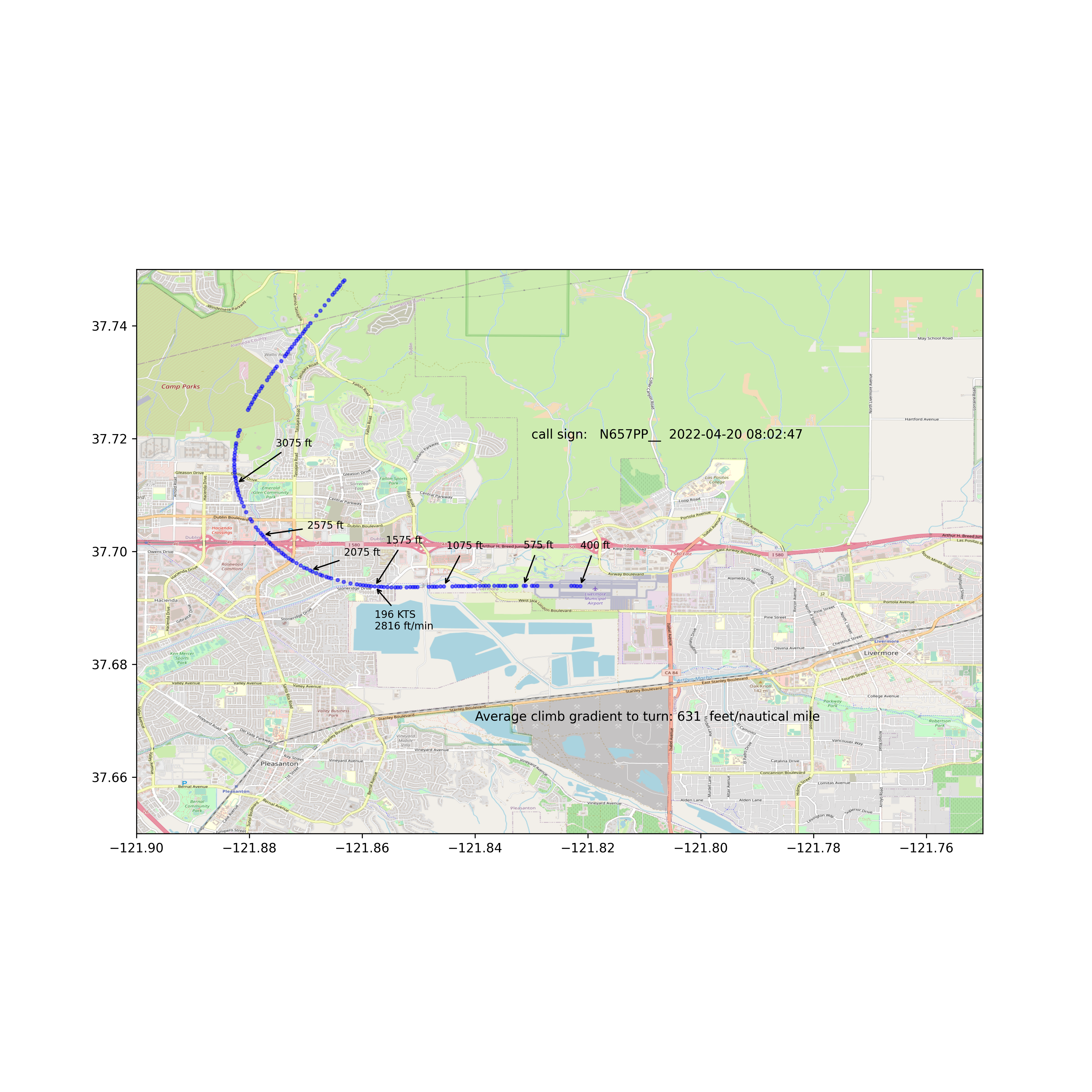
Attention is called to a couple of these “not so good” departures, the first (a941b2) is a Gulfstream G280 that departed April 11 at 12:26 PM (owner/operator: HENRY CROWN AND COMPANY S LLCDBA, CC INDUSTRIES). The pilot operated the aircraft at a rather low climb gradient of 615 feet per nautical mile. This aircraft can easily climb at twice this value. The jet entered the airspace over the residential area at 1075 feet above the ground, a height not particularly high which is not conducive to minimizing noise, and then overflew the entire residential area while making its turn north.
The second one regards the departure of a8a80e, a Lear Jet Model 45 registered to Peterson Holding Co. of San Leandro that departed April 13 at 8:17 AM. A similar analysis reveals a paltry climb gradient of 670 feet per nautical mile placing it about 1100 feet above the residential neighborhood in a manner similar to the previous example. These examples demonstrate that how the pilot operates the aircraft can result in a noisy departure affecting an entire neighborhood or one that is much less noisy and affects far fewer people. (Added April 20, 2022: This same aircraft departed 8:02 AM and executed a nearly identical departure to the one on April 13. a8a80e)
The “good” departures exhibit typically double the climb gradient of the “not so good” and typically are turning north prior to overflying the residential area. All of these jets are high performance machines and have the capability to climb rapidly and execute the LVK Three Departure in a manner that minimizes overflight of the residential area to the west.
A Suggestion
This author does not know if there is any effort to make the transient jet pilots aware of the noise issue to the west. There may be, but it does seem there is no official voluntary advisory that addresses LVK Three departures to the west. In the same spirit the VFR noise abatement advisory asks pilots to safely execute heading maneuvers when able to do so, it would seem no worse to ask IFR jet departures to safely execute a high climb gradient when able to do so. Making an advisory official would then promote its communication to the many transient jet pilots not aware of the local conditions at LVK.
Hardware and Software
To capture the ADS-B broadcasts from aircraft an RTL-SDR software defined radio (~$30) was used and fed with a homemade quarter-wave antenna to receive the 1090 MHz signal. This device is connected to the USB port of a Jetson Nano (~$100) running Ubuntu 18.04 and the open source software package dump1090-mutability was downloaded and built on the Nano. The raw data output of dump1090 was streamed in parallel to two Python scripts. These scripts use the Python library called pyModeS. One script interprets the stream to find aircraft on the ground, searches a database to determine if it is a jet, and if so puts that aircraft on a list. The second script interprets the stream to compare to jets on the list, and detects when a listed jet leaves the ground, subsequently tracking and recording its ADS-B broadcasts for 3 minutes. Various shell scripts and Python code take the data, analyze it, and create the annotated map image. The map is built with tiles from openstreetmap.org and a python script uses the matplotlib library to create the map.


Recent Comments